Showing 47 items matching farming (kew)
-
 Kew Historical Society Inc
Archive (Sub-series) - Subject File, Farming (Kew), 1958
... Farming (Kew)...kew (vic) - farming... Subject File Archive Farming (Kew) Archive file containing ...Various partiesReference, Research, InformationSecondary Values (KHS Imposed Order)Subject file containing a newspaper article/clipping called ‘Our Pastoral Routes’ by Jenny Brown.kew (vic) - history, kew (vic) - farming, kew (vic) - dairies, kew (vic) - agriculturekew (vic) - history, kew (vic) - farming, kew (vic) - dairies, kew (vic) - agriculture -
 Kew Historical Society Inc
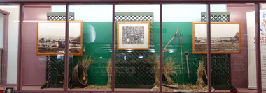
Photograph - Born Digital Photograph, Robert Baker, Farming in Kew, Kew Library, 2014
... Farming in Kew, Kew Library, 2014... of historic photographs and items relating to farming in Kew... Digital Photograph Photograph Farming in Kew, Kew Library, 2014 ...Photograph of a small display in the showcase at Kew LibraryBorn digital image of a display in the Kew Library of historic photographs and items relating to farming in Kew. The display was mounted using Kew Historical Society images and artefacts.kew (vic) - agriculture, exhibitions - kew historical society -
Kew Historical Society Inc
Archive (Sub-series) - Subject File, Belford Farm (Kew East), 1958
... farming -- kew (vic)... and secondary sources. wade family - kew (vic.) farming -- kew (vic) ...Various partiesReference, Research, InformationKHS OrderSubject file containing genealogical research material on the Wades of Belford Farm, all photocopied. One item was prepared for a reunion of the descendants of Peter Robert & Mary Ann Mansergh (Blair) and James & Maria Mullins (Dartnell) who arrived in the Colony on the Sailing Ship ‘China’ on 1 May 1840. The item includes lists of passenger names and the names of their descendants. The other item is an inquiry from Elvania Balcombe, which includes her own research into the Wade family.wade family - kew (vic.), farming -- kew (vic)wade family - kew (vic.), farming -- kew (vic) -
 Kew Historical Society Inc
Photograph, Kew looking East to Deepdene, c.1905
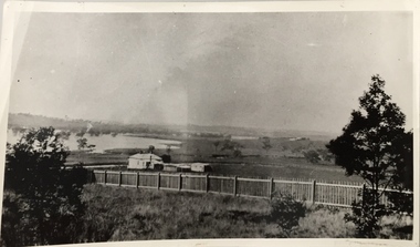
... farming (kew)... etc) deepdene farming (kew) ...Kew looking east towards Deepdene. Before 1909. The reverse of the photograph includes an analysis of the photo and the places that can be seen within it (eg Deepdene Station, first Deepdene School, Burke Road etc)deepdene, farming (kew) -
 Kew Historical Society Inc
Photograph, Kew looking East to Deepdene, c.1905
... farming (kew)... etc) farming (kew) deepdene ...Kew looking east towards Deepdene. Before 1909. The reverse of the photograph includes an analysis of the photo and the places that can be seen within it (eg Deepdene Station, first Deepdene School, Burke Road etc)farming (kew), deepdene -
 Kew Historical Society Inc
Photograph, Wade's Farm, Kilby Road, Nineteenth Century
... farming (kew)... Torpey) wade's farm farming (kew) kilby road north kew belford ...""The public trial of reaping machines, under the auspices of the Port Phillip Farmers' Society, advertised to take place on Friday, last, but postponed on account of the weather, came off December 27. The place selected (Mr. Wade's farm, Belford, near Kew) is undulating ground, with a remarkably heavy crop of wheat upon it. This, taken in connection with, the state of the ground, still soft from the recent rains, made the trial an uncommonly severe one. ..."(South Australian Advertiser, 15 January 1859) Some bricks used in Kew buildings came from the brickworks on Wade's Farm at the end of Belford Road near the Yarra River (now part of the Kew Golf Club). (History of RSL by John Torpey)Wade's Farm, Kilby Road, Kew.wade's farm, farming (kew), kilby road, north kew, belford road, kew, kew golf club -
 Kew Historical Society Inc
Photograph, Kilby Road, North Kew, 1916
... farming (kew)... E. Bennett, Kew East." north kew farming (kew) wade's farm ...Kilby Road, North Kew 1916. Annotation Reverse: "Kilby Road about 1916. Courtesy Mrs E. Bennett, Kew East."north kew, farming (kew), wade's farm (kew) -
 Kew Historical Society Inc
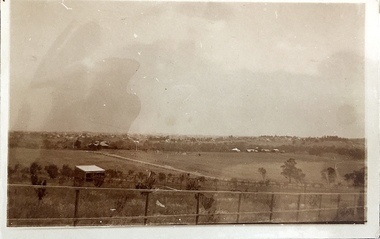
Photograph - Yarra Valley at Kew, 1912
... farming -- kew (vic.)... in Kew was devoted to dairy farming. In the twentieth century ...During the nineteenth century, the land abutting the south side of the Yarra in Kew was devoted to dairy farming. In the twentieth century, before and after the construction of the Eastern Freeway, much of this low-lying area was used as golf courses and public parks.Real-photo postcard of the farmland in the Yarra Valley in what is believed to be North Kew in 1912. Verso: "Willsmere / East Kew / 1912"yarra river, yarra valley, farming -- kew (vic.) -
 Kew Historical Society Inc
Photograph, City of Kew, Hays Paddock, Kew East, c.1980
... kew (vic) - farming...) - history kew (vic) - public parks kew (vic) - farming City of Kew ...One of a series of photos created for an exhibition by the City of Kew of notable locations. The photos represent a snapshot in time.Enlarged photograph mounted on board, donated to the Kew Historical Society by the City of Kew on 10 April 1991.hays paddock - kew east (vic), kew (vic) - history, kew (vic) - public parks, kew (vic) - farming -
 Kew Historical Society Inc
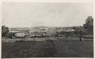
Photograph, J F C Farquhar, Kew Asylum & Grounds, 1891
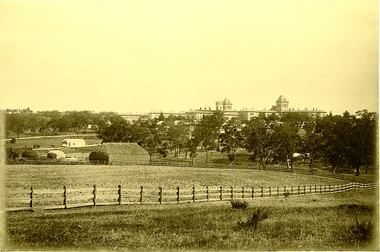
At the beginning of the 1890s, the Kew businessman and Town Councillor, Henry Kellett, commissioned J.F.C. Farquhar to photograph scenes of Kew. These scenes included panoramas as well as pastoral scenes. The resulting set of twelve photographs was assembled in an album, Kew Where We Live, from which customers could select images for purchase.The preamble to the album describes that the photographs used the ‘argentic bromide’ process, now more commonly known as the gelatine silver process. This form of dry plate photography allowed for the negatives to be kept for weeks before processing, hence its value in landscape photography. The resulting images were considered to be finely grained and everlasting. Evidence of the success of Henry Kellett’s venture can be seen today, in that some of the photographs are held in national collections.It is believed that the Kew Historical Society’s copy of the Kellett album is unique and that the photographs in the book were the first copies taken from the original plates. It is the first and most important series of images produced about Kew. The individual images have proved essential in identifying buildings and places of heritage value in the district.When the Kew Lunatic Asylum was opened in 1871, its extensive 340 acres of grounds were intended for farming, agriculture and recreation for the inmates. The point-of-view chosen by Farquhar for this panoramic photograph focuses on the ordered open fields, haystacks and remnant trees that extended from the foreground to the rear of the Asylum. The inmates are the absent players in this pastoral idyll. In 1891, The Argus reported on the Annual Asylum Picnic: “Wednesday saw the Kew picnic, the yearly festival of the mad folks and their keepers. Once a year the public subscribes for cakes and ale for all these mad folks, and their keepers, from superintendent to lowest wardsman, turn out, and use their best endeavours to make one day in the year sanely merry.” Regardless of such merriment, the Asylum’s development and ongoing status were frequently a source of disquiet to the residents of Kew, who regularly petitioned the State Government for its removal. Despite these views, the Asylum was to remain a functioning institution from 1871 to 1988. Kew Asylum & Groundskew illustrated, kew where we live, photographic books, henry kellett, kew lunatic asylum -
 Kew Historical Society Inc
Photograph, J F C Farquhar, The Yarra in Hyde Park, 1891
At the beginning of the 1890s, the Kew businessman and Town Councillor, Henry Kellett, commissioned J.F.C. Farquhar to photograph scenes of Kew. These scenes included panoramas as well as pastoral scenes. The resulting set of twelve photographs was assembled in an album, Kew Where We Live, from which customers could select images for purchase.The preamble to the album describes that the photographs used the ‘argentic bromide’ process, now more commonly known as the gelatine silver process. This form of dry plate photography allowed for the negatives to be kept for weeks before processing, hence its value in landscape photography. The resulting images were considered to be finely grained and everlasting. Evidence of the success of Henry Kellett’s venture can be seen today, in that some of the photographs are held in national collections.It is believed that the Kew Historical Society’s copy of the Kellett album is unique and that the photographs in the book were the first copies taken from the original plates. It is the first and most important series of images produced about Kew. The individual images have proved essential in identifying buildings and places of heritage value in the district.Hyde Park is now a small recreation reserve bordered by Willsmere and Kilby Roads and White Avenue. In 1982, Hyde Park was cut off from the Yarra River by the construction of the Eastern Freeway. The building of the latter was to transform the natural landscape, including the Yarra, as well as Hyde Park. The construction of the Freeway makes it difficult to view the scene with the photographer’s eye. Today’s Hyde Park is located on land purchased in 1847 by John Cowell, and in 1851 Catherine Cowell, yet the scene selected by the photographer may well have been located on farmland owned by the Wills family. Farquhar’s point-of-view emphasises both the pastoral and recreational elements of the scene: the grazing cows, three boys, and in the distance two figures, seated on the bank with a parasol. By 1891, an environmental consequence of human activity, including farming, was deforestation, leading to the erosion of the south bank of the Yarra. In contrast, the land on the Alphington side of the river in 1891 included remnant bushland.The Yarra in Hyde Parkkew illustrated, kew where we live, photographic books, henry kellett, yarra river -
 Kew Historical Society Inc
Photograph - Yarra at Kew, 1925
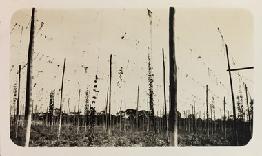
Henry Beater Christian (1886-1962) , was a descendant of one of the earliest settler families in Kew. Employed at the Kew Asylum as a 'public servant', he was a skilled amateur photographer, photographing numerous scenes in Kew and on his travels around Victoria. The majority of his photographs date from 1916 to 1929. His finest photographs are housed in two photograph albums. Digital copy of a photograph from page 4 of the 47-page photograph album containing 261 gelatinous silver images, loaned by Diane Washfold with permission given to digitise and hold a copy in our collection. This photograph of hop farming coveys the various uses for which low lying fertile flood prone land beside the Yarra River was used."Yarra at Kew"henry beater christian (1886-1962), landscape photography, kew (vic.) — yarra river, christian-washfold collection, photograph albums, agriculture, hop farms -
![Painting: Park Street [Adeney Avenue] Kew](https://victoriancollections.net.au/media/collectors/550653872162f11fb04854aa/items/5826877cd0cdd11284ad5413/item-media/614ac683a53a0756fd5e49da/item-fit-380x285.jpg) Kew Historical Society Inc
Kew Historical Society IncPainting, Park Street [Adeney Avenue] Kew, c. 1896
‘Adeney Avenue’ was the title given to this painting following its donation to the Kew Historical Society, yet the work’s origins predate the naming of Adeney Avenue in 1907 [originally gazetted as ‘Park Street’ (1865) and ‘Park Street South’ (1875).] Park Street ran between High Street and Parkhill Road beside what was later to become ‘Victoria Park’. This area was described in 1851 as “…a dense forest of gums and wattles which were to be largely cleared by 1888 after the naming of a recreation reserve”. The Reserve was still bisected by an unnamed creek in 1896, when the area was surveyed by the MMBW. The panoramic vista selected by the artist would appear to include ‘Eborensis’ (c.1895) on the corner of Parkhill Road and what was then Park Street, with views across cleared land towards the distant ranges. In the 19th century, north Kew was largely undeveloped farms stretching down to the Yarra. Oil on canvas by an unidentified artist of a panoramic view depicting what is now known as East Kew with mountains on the horizon. In the foreground is a two storey brick residence - Eborensis - located on the northeast corner of Parkhill Road and what is now Adeney Avenue. The view of the landscape and its rolling hills resulted from farming practices adopted following colonisation and settlement. Trees in the foreground and in the distance include remnant Eucalypts and introduced exotics.Label on rear of frame states "House on corner of Adeney Ave & Parkhill. [Regd. 254"]. Otherwise unsigned and undatedadeney avenue (kew), eborensis, park street (kew) -
 Kew Historical Society Inc
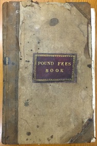
Administrative record (item), Borough of Kew, Pound Fees Book, 1874-1896
While the first successful land sales in Boroondara occurred in Hawthorn in 1843, and Kew in 1845, these areas were to be without local pounds until April 1858, when the Governor of Victoria, in accordance with Act 18 Victoria No 30, was pleased to direct the establishment of a Pound at Glass’s Creek on that part of land bounded by the Kilby Road, Burke Road and High Street. While the Governor was required to proclaim the establishment of a pound, the appointment of a poundkeeper was the responsibility of the Justices of the Peace in the local Court of Petty Sessions. The Pound took its name from the most distinctive natural feature of the area, Glass’s Creek, named after the early pastoralist Thomas Glass.The register is of historic significance as an indicator of suburban life in the second half of the 19th Century. It shows how farming and city life on the urban fringe were intimately connected. It is also significant to the early history of Hawthorn and Kew, who both claimed the Pound following their separation from the Boroondara Roads Board in 1861."Kew Pound Book"glass creek pound (kew), animal pound, dog pound, kew pound, j. smith, john oakes, samuel b. cash, edward s. delaney, emma oswin, samuel cash -
 Kew Historical Society Inc
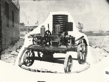
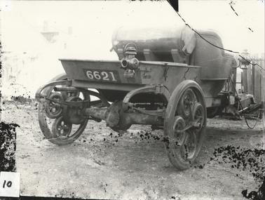
Photograph, Agricultural Equipment, c.1920
... to the Society by Ian McKenzie, a professional photographer in Kew ...This photograph was printed from a glass negative held in the Society's picture collection. The original glass negative is part of a set donated to the Society by Ian McKenzie, a professional photographer in Kew. Agricultural equipment, ca. 1910-ca. 1920. An elaborate piece of farm machinery powered by a small engine. The four-wheeled unit has a tank and a hose. The purpose of both is unclear. Like a number of glass negatives in the Collection, this plate has been reused. The original photograph shows houses in a streetscape. In the distance is an advertisement for starch, roughly painted on a fence.agriculture, glass negatives, farming equipment -
 Kew Historical Society Inc
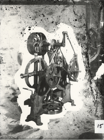
Photograph, Stationery Engine, c.1921
... photographer in Kew. stationery engine farming technology farming ...This photograph was printed from a glass negative held in the Society's picture collection. The original glass negative is part of a set donated to the Society by Ian McKenzie, a professional photographer in Kew. Stationary engine, After 1920. A print from a glass negative that has been reused to document an early stationary engine. The equipment, designed to be bolted to a larger object such as a floor, is comprised of wheels and shafts. The content of the original photograph is too unclear to be identified. stationery engine, farming technology, farming equipment, glass negatives -
 Kew Historical Society Inc
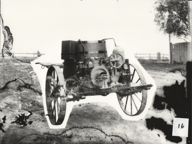
Photograph, Agricultural Equipment, c.1921
... photographer in Kew. agriculture farming machinery glass negatives ...This photograph was printed from a glass negative held in the Society's picture collection. The original glass negative is part of a set donated to the Society by Ian McKenzie, a professional photographer in Kew. Agricultural equipment, After 1920. A print from a glass negative that has been reused to document an item of equipment used on a farm. The equipment is vehicular and designed to be hauled behind another form of transport, either equine or mechanical. On the vehicle, there is a motor at the rear. The main part of the vehicle is a barrel that might have been used to hold liquid or solids. The original photograph would appear to be a scene adjacent to a beach. The photo was printed from a glass negative in the collection. The original glass negative is part of a set donated to the Society by Ian McKenzie.agriculture, farming machinery, glass negatives -
 Kew Historical Society Inc
Photograph, Converted Automobile, c.1920
... photographer in Kew. farming machinery automobiles glass negatives ...This photograph was printed from a glass negative held in the Society's picture collection. The original glass negative is part of a set donated to the Society by Ian McKenzie, a professional photographer in Kew. Early automobile, ca. 1910-ca. 1920. A photograph of an early automobile, of indeterminate make. The automobile has its fuel tank behind the passenger seat. The vehicle is missing its front tyres and appears to be converted to allow it to be towed by another automobile or a horse. farming machinery, automobiles, glass negatives -
 Kew Historical Society Inc
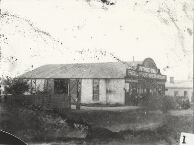
Photograph, Patmore & Dinham, Scottsdale, 1910-1920
This photograph was printed from a glass negative held in the Society's picture collection. The original glass negative is part of a set donated to the Society by Ian McKenzie, a professional photographer in Kew. Patmore & Dinham, Scottsdale, ca. 1910 - ca. 1920. A large corrugated iron store owned by ‘Patmore & Dinham: Produce, Manure and General Merchants’. The store was located in Scottsdale, northeast Tasmania. For more than forty years, George Melville Dinham had occupied a prominent position in the Scottsdale community. He and his partner, Mr. Patmore were to ultimately own four businesses in this farming town, of which this is one.patmore & dinham, scottsdale, glass negatives -
 Kew Historical Society Inc
Photograph - Yarra Valley Floods: Kew East, 1916
Flooding of the Yarra Valley, including that section of the Yarra bordering Kew and Kew East in the north and west of the municipality, was a regular occurrence. Extreme flood events of the Yarra River are recorded to have occurred in 1891, 1901, 1916, 1923 and 1934. The Municipality of Kew's response to these floods was to enact planning decisions restricting residential development in flood prone areas following the floods of 1916, 1921 and 1934. While floods continued after the development of the Upper Yarra Reservoir (construction 1948-57), the regularity and extent of these inundations diminished. During the nineteenth century, the land abutting the south side of the Yarra in Kew was devoted to dairy farming. In the twentieth century, before and after the construction of the Eastern Freeway, much of this low-lying area was used as golf courses and public parks.One of a collection of photographs of flooding in the Kew section of the Yarra Valley which are in important research resource for the location and extent of flooding in the first half of the twentieth century. Flooding of the Yarra Valley at East Kew in 1916. The view is taken from the intersection of Kilby Road with what is believed to be Birdwood Street, looking across the flood waters to Ivanhoe. The extensive flooded area shown in the photograph would have included the Kew Golf Club. Verso: "Floods along Kilby Road / near Birdwood St? & Kilby Road / 1917? / 87yarra river, yarra valley, floods -- kew, kilby road -- kew (vic.), kew golf club -
 Kew Historical Society Inc
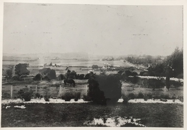
Photograph - Yarra Valley at Kew, 1918
During the nineteenth century, the land abutting the south side of the Yarra in Kew was devoted to dairy farming. In the twentieth century, before and after the construction of the Eastern Freeway, much of this low-lying area was used as golf courses and public parks.View of the farmland in the Yarra Valley at what is believed to be East Kew in 1918. Verso: "Willsmere / East Kew? / 1918"yarra river, yarra valley -
 Kew Historical Society Inc
Photograph - Yarra Valley Floods: Kew East, 1916
Flooding of the Yarra Valley, including that section of the Yarra bordering Kew and Kew East in the north and west of the municipality, was a regular occurrence. Extreme flood events of the Yarra River are recorded to have occurred in 1891, 1901, 1916, 1923 and 1934. The Municipality of Kew's response to these floods was to enact planning decisions restricting residential development in flood prone areas following the floods of 1916, 1921 and 1934. While floods continued after the development of the Upper Yarra Reservoir (construction 1948-57), the regularity and extent of these inundations diminished. During the nineteenth century, the land abutting the south side of the Yarra in Kew was devoted to dairy farming. In the twentieth century, before and after the construction of the Eastern Freeway, much of this low-lying area was used as golf courses and public parks.One of a collection of photographs of flooding in the Kew section of the Yarra Valley which are in important research resource for the location and extent of flooding in the first half of the twentieth century. Flooding of the Yarra Valley at East Kew in 1916. The view is taken from a street (maybe Birdwood Avenue) intersecting with Kilby Road looking northeast across the flood waters to Ivanhoe and Heidelberg. The extensive flooded area shown in the photograph would have included remnant dairy farms and the Kew Golf Club. Verso: "Floods / Yarra River / East Kew / Kilby Road / 1917? / 87"yarra river, yarra valley, floods -- kew, kilby road -- kew (vic.), kew golf club -
 Kew Historical Society Inc
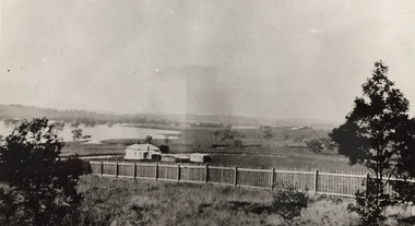
Photograph - Yarra Flats near Burke Road Bridge, 1937
Land along the Yarra River in Kew is now either designated open space, parkland or public golf links. By the 1930s much of this area remained open farmland, bought at auction for dairy farming in the 1840s.Original, black and white positive print of what is said to be the Yarra Flats near Burke Road Bridge. On the horizon, building can be seen, whereas in the middle ground, farm fencing and a windmill are the main features as well as remnant Eucalypts. Inscribed verso: "Yarra Flats near Burke Rd Bridge 1937" studley park -- kew (vic.) -
 Kew Historical Society Inc
Photograph - Flooding of the Yarra Valley at Kew East, 1974
Flooding of the Yarra Valley, including that section of the Yarra bordering Kew and Kew East in the north and west of the municipality, was a regular occurrence. Extreme flood events of the Yarra River are recorded to have occurred in 1891, 1901, 1916, 1923 and 1934. The Municipality of Kew's response to these floods was to enact planning decisions restricting residential development in flood prone areas following the floods of 1916, 1921 and 1934. While floods continued after the development of the Upper Yarra Reservoir (construction 1948-57), the regularity and extent of these inundations diminished. During the nineteenth century, the land abutting the south side of the Yarra in Kew was devoted to dairy farming. In the twentieth century, before and after the construction of the Eastern Freeway, much of this low-lying area was used as golf courses and public parks.Late example of the capacity of the Yarra Valley at Kew to flood, even though drainage works and the Upper Yarra Reservoir had reduced their regularity.Original black and white print photograph of the low-lying land at East Kew under floodwater on 16 May 1974. The vantage point of the photographer is Lister Street. In the photo, the fences of the Kilby Farm can be seen. Flooding was caused by overflowing water in Glass' Creek and the River Yarra. Annotation verso: "Hay's Paddock op No.30 Lister Street / 16 May 1974 11.50am / R.L. 46.04"hays paddock, floods, yarra river, glass' creek, lister street -
 Kew Historical Society Inc
Photograph - Flooding of the Yarra Valley at Kew East, 1974
Flooding of the Yarra Valley, including that section of the Yarra bordering Kew and Kew East in the north and west of the municipality, was a regular occurrence. Extreme flood events of the Yarra River are recorded to have occurred in 1891, 1901, 1916, 1923 and 1934. The Municipality of Kew's response to these floods was to enact planning decisions restricting residential development in flood prone areas following the floods of 1916, 1921 and 1934. While floods continued after the development of the Upper Yarra Reservoir (construction 1948-57), the regularity and extent of these inundations diminished. During the nineteenth century, the land abutting the south side of the Yarra in Kew was devoted to dairy farming. In the twentieth century, before and after the construction of the Eastern Freeway, much of this low-lying area was used as golf courses and public parks.Late example of the capacity of the Yarra Valley at Kew to flood, even though drainage works and the Upper Yarra Reservoir had reduced their regularity.Original black and white print photograph of the low-lying land at East Kew under floodwater on 16 May 1974. The vantage point of the photographer is Lister Street. Flooding was caused by overflowing water in Glass' Creek and the River Yarra. Annotation verso: "Lister Street looking north / Flood level / 16 May 1974 11.30am / R.L. 46.04"hays paddock, floods, yarra river, glass' creek, lister street -
 Kew Historical Society Inc
Photograph - Flooding of the Yarra Valley at Kew East, 1974
Flooding of the Yarra Valley, including that section of the Yarra bordering Kew and Kew East in the north and west of the municipality, was a regular occurrence. Extreme flood events of the Yarra River are recorded to have occurred in 1891, 1901, 1916, 1923 and 1934. The Municipality of Kew's response to these floods was to enact planning decisions restricting residential development in flood prone areas following the floods of 1916, 1921 and 1934. While floods continued after the development of the Upper Yarra Reservoir (construction 1948-57), the regularity and extent of these inundations diminished. During the nineteenth century, the land abutting the south side of the Yarra in Kew was devoted to dairy farming. In the twentieth century, before and after the construction of the Eastern Freeway, much of this low-lying area was used as golf courses and public parks.Late example of the capacity of the Yarra Valley at Kew to flood, even though drainage works and the Upper Yarra Reservoir had reduced their regularity.Original black and white print photograph of Hay's Paddock under floodwater on 16 May 1974. The vantage point of the photographer is Keystone Crescent looking east. Flooding was caused by overflowing water in Glass' Creek and the River Yarra. Annotation verso: "Keystone Cr looking east / 16 May 1974 11.50am"hays paddock, floods, yarra river, glass' creek -
 Kew Historical Society Inc
Photograph - Flooding of the Yarra Valley at Kew East, 1974
Flooding of the Yarra Valley, including that section of the Yarra bordering Kew and Kew East in the north and west of the municipality, was a regular occurrence. Extreme flood events of the Yarra River are recorded to have occurred in 1891, 1901, 1916, 1923 and 1934. The Municipality of Kew's response to these floods was to enact planning decisions restricting residential development in flood prone areas following the floods of 1916, 1921 and 1934. While floods continued after the development of the Upper Yarra Reservoir (construction 1948-57), the regularity and extent of these inundations diminished. During the nineteenth century, the land abutting the south side of the Yarra in Kew was devoted to dairy farming. In the twentieth century, before and after the construction of the Eastern Freeway, much of this low-lying area was used as golf courses and public parks.Late example of the capacity of the Yarra Valley at Kew to flood, even though drainage works and the Upper Yarra Reservoir had reduced their regularity.Original black and white print photograph of the low-lying land at East Kew under floodwater on 16 May 1974. The vantage point of the photographer is Lister Street. Flooding was caused by overflowing water in Glass' Creek and the River Yarra. Annotation verso: "Lister St looking same as No.3 / 16 May 1974 11.30"floods, yarra river, glass' creek, lister street -
 Kew Historical Society Inc
Photograph - Flooding of the Yarra Valley at Kew East, 1974
Flooding of the Yarra Valley, including that section of the Yarra bordering Kew and Kew East in the north and west of the municipality, was a regular occurrence. Extreme flood events of the Yarra River are recorded to have occurred in 1891, 1901, 1916, 1923 and 1934. The Municipality of Kew's response to these floods was to enact planning decisions restricting residential development in flood prone areas following the floods of 1916, 1921 and 1934. While floods continued after the development of the Upper Yarra Reservoir (construction 1948-57), the regularity and extent of these inundations diminished. During the nineteenth century, the land abutting the south side of the Yarra in Kew was devoted to dairy farming. In the twentieth century, before and after the construction of the Eastern Freeway, much of this low-lying area was used as golf courses and public parks.Late example of the capacity of the Yarra Valley at Kew to flood, even though drainage works and the Upper Yarra Reservoir had reduced their regularity.Original black and white print photograph of the low-lying land at East Kew under floodwater on 16 May 1974. The vantage point of the photographer is at Willsmere Road. The road itself is underwater.Annotation verso: "Willsmere Rd / Same as No.7 / 16 May 1974 11.15am"floods, yarra river, willsmere road -
 Kew Historical Society Inc
Photograph - Flooding of the Yarra Valley at Kew East, 1974
Flooding of the Yarra Valley, including that section of the Yarra bordering Kew and Kew East in the north and west of the municipality, was a regular occurrence. Extreme flood events of the Yarra River are recorded to have occurred in 1891, 1901, 1916, 1923 and 1934. The Municipality of Kew's response to these floods was to enact planning decisions restricting residential development in flood prone areas following the floods of 1916, 1921 and 1934. While floods continued after the development of the Upper Yarra Reservoir (construction 1948-57), the regularity and extent of these inundations diminished. During the nineteenth century, the land abutting the south side of the Yarra in Kew was devoted to dairy farming. In the twentieth century, before and after the construction of the Eastern Freeway, much of this low-lying area was used as golf courses and public parks.Late example of the capacity of the Yarra Valley at Kew to flood, even though drainage works and the Upper Yarra Reservoir had reduced their regularity.Original black and white print photograph of the low-lying land at East Kew under floodwater on 16 May 1974. The photograph is of Hyde Park looking north-east.Annotation verso: "Hyde Park looking nth-east / Flood Level / 16 May 1974 11.15am / R.L. 46.61"floods, yarra river, hyde park -
 Kew Historical Society Inc
Photograph - Flooding of the Yarra Valley at Kew, 1974
Flooding of the Yarra Valley, including that section of the Yarra bordering Kew and Kew East in the north and west of the municipality, was a regular occurrence. Extreme flood events of the Yarra River are recorded to have occurred in 1891, 1901, 1916, 1923 and 1934. The Municipality of Kew's response to these floods was to enact planning decisions restricting residential development in flood prone areas following the floods of 1916, 1921 and 1934. While floods continued after the development of the Upper Yarra Reservoir (construction 1948-57), the regularity and extent of these inundations diminished. During the nineteenth century, the land abutting the south side of the Yarra in Kew was devoted to dairy farming. In the twentieth century, before and after the construction of the Eastern Freeway, much of this low-lying area was used as golf courses and public parks.Late example of the capacity of the Yarra Valley at Kew to flood, even though drainage works and the Upper Yarra Reservoir had reduced their regularity.Original black and white print photograph of the low-lying land at East Kew under floodwater on 16 May 1974. The photograph is taken from 43 Kellett Grove.Annotation verso: "Kellett Gve No.43 / Flood Level / 16 May 1974 11.40am"floods, yarra river, kellett grove